


- Inicio
- Trabajos en curso
- PILOT EXPERIENCE IN NAVARRA
PILOT EXPERIENCE IN NAVARRA
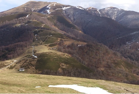
LOCATION
- South slope of the Western Pyrenees. Sector NW of the LIC Roncesvalles-Selva de Irati.
- Coordinates: 43º1’N 1º19’W
- Altitude range: 1062 m (Collado de Ibañeta) up to 1567 m (Ortzanzurieta).
- Municipal district: Roncesvalles (Navarra)
- Property of the land: Royal Collegiate of Roncesvalles
PROTECTION FIGURES
“Roncesvalles-Selva de Irati (ES0000126)” Place of Community Interest. ZEC Roncesvalles-Selva de Irati approved in Autonomous Community Decree 9/2011 on 7th February.
ACTION SURFACES AREAS
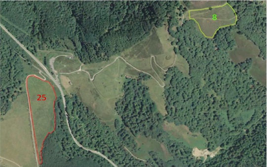
Two surface areas have been selected: 2.55 ha (plot 8) and 3.86 ha (plot 25), respectively, for the combined and monitored practices of controlled burn and guided grazing. The guided use for the improvement of these surfaces areas will be complemented by the grazing of nearby improved pastures that occupy a surface area of almost 125 ha. For the assessment of the meat product, extensive fodder of 60 indigenous breed colts will be implemented in the improved pastures.
CLIMATE
Cold and oceanic, characterised by snowy winters and cool summers. Annual mean temperature of 9.2ºC and average rainfall of 1.601 mm (Espinal meteorological station).
VEGETATION
The area includes a total of 325 hectares that extend to the west and to the east of the Ibañeta hill to the Ortzanzurieta peak, forming a patchwork of beech forests (Fagus sylvatica), heaths-shrubs (Erica vagans, Erica cinerea, Calluna vulgaris, Daboecia cantabrica, Ulex gallii and Pteridium aquilinum), shrubs (Ulex gallii) and acidophil mountain pastures (with Agrostis capillaris, Agrostis curtisii, Festuca nigrescens ssp. microphylla, Danthonia decumbens, Galium saxatile and Potentilla erecta, among other species).
Ulex gallii shrubs constitute in the study area dense shrublands in pre-mature phase (4-15 years), mature phase (16-25 years) or post-mature phase (over 25 years) depending on the time elapsed after the last action (burn, intense grazing or clearing).
GEOLOGY AND SOILS
Black schist and schist with quartzites dominate in the north. In south-western areas and at low levels, schist and sandstones. The soils according to the USDA taxonomy are classified as Humic Dystrudept and Typic Udorthent and are characterised by being very organic, strongly acidic, with a dominant silt texture and high capacity for cation exchange. The total content of nitrogen, phosphorous and potassium are high and there is a high fraction of changeable aluminium due to the soil’s high acidity.
ENVIRONMENTAL PROBLEMS ASSOCIATED WTH PE
Heather and gorse cover extensive areas of Atlantic regions in western Europe, settling on acidic and oligotrophic lands. In the last century, they have undergone an intense step back in much of their natural distribution area caused by the rupturing of the land for agricultural uses and due to the evolution to other plant communities due to eutrophication (deposition of nitrogen). Conversely, in the north of the Iberian Peninsula the communities are expanding, encouraged by the abandonment of agrarian activities and by the relaxation of farming use in the most unfavourable areas. However, the management is not appropriate and heather and gorse can evolve to dense shrub. While they should be serial communities, with capacity to evolve towards shrub forestry systems, shrublands with abundant gorse (Ulex sp) are very closed and stable communities that are hard to access, and develop and accumulate a large amount of biomass. Gorse is a flammable bush that combusts and quickly spreads flames, and can reach high burn intensities. Control of the fire on these surface areas is difficult and there is a risk of spreading to adjacent areas. In the face of the current situation of global change, the importance can be seen of controlling this combustible biomass and favouring less dense and more open shrubland with greater biodiversity.
USE OF CONTROLLED FIRE
In temperate and Pyrene Navarra, the use of pasture fire is a traditional practice carried out in the winter period primarily to control the shrubland and is regulated by the regional administration primarily to reduce the risk of escape (Autonomous Community Law 3/2007 of 21st February and subsequent Autonomous Community Orders, BON (Navarra Official Bulletin) 4th July 2016). The legislation prescribes a period of time in which these practices can be carried out and classifies burns according to danger, the participation of special brigades (EPRIF) being necessary in the most compromised actions. The balance of these biomass control actions is very unequal and, generally, rapid bush regrowth is often seen in recently burned areas. Ineffective control of shrubland entails a loss of resources and money.
In the study area, different controlled burns were carried out in 1998-2000. More recently, in 2014, controlled burns (spring) and mechanical clearings (summer) were carried out in different areas densely covered in broom. Plot 8 was burned in winter 2014. Plot 25 was mechanically cleared in 2006. Both plots currently (2018) have a medium-high covering of broom.
CENSUSES OF GRAZING HERBIVORES
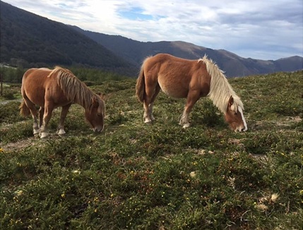
In the action zones and their surroundings, grazing has taken place in recent years by two flocks of latxas sheep, a small flock (10-16 UGM) of blond breed heifers and, since 2014, groups of studs with low maintenance needs (37-48 UGM) from the Burguete breed (belonging to farmers from the area) and Jaca Navarra breed (belonging to INTIA), who graze the zone for 8-9 months.
FARMING INFRASTRUCTURES AND ACCESSES
The study zone is accessed via Highway N-135 up to Ibañeta hill and via forest trail paths. The zone has different short cuts (a natural ditch and three watering holes) and a livestock handling sleeve supplied with scales to weight the animals. There are also 5,500 linear metres of fixed electric fencing and 1,100 m of fixed barbed wire fencing, with different passages and Canadian barriers with walking passage – it is an area frequented by walkers (Camino de Santiago).
Near the study zone, in the same municipality, the INTIA partner has ovine livestock use with a significant territorial base and provision of farm infrastructures, with different demonstrative and dissemination experiences being undertaken therein. In 2018, the Ordantzaro area (including plot 8), has been grazed por 12-15 studs (from the fourth week of August until the intense snowfall at the end of the year), and the Girizu area (where plot 25 is located), which was grazed by 10-11 studs in April-May and 33 studs from June to mid-August. This latter zone has also been grazed by sheep (80 animals from June to August and a flock of 450 animals from late August to early October. For the pilot experience, the presence of 2 to 6 studs/ha has been scheduled. The animals will change plot when the grazing on offer has finished and will return after successive re-growth.
#CalidadSuelosAplicacionesMedioambiente
Follow us


Project financed 75% by the European Regional Development Fund

Universidad Publica de Navarra
Edificio Jerónimo de Ayanz, Campus Arrosadía
31006 Pamplona