


- Inicio
- Trabajos en curso
- PILOT EXPERIENCE IN MONTSENY (Catalonia)
PILOT EXPERIENCE IN MONTSENY (Catalonia)
LOCATION
- Montseny Natural Park and Biosphere Reserve, Catalan Pre-Coastal Range
- Coordinates: UTM31N, E:443445.7 and N:4622876.1
- Altitudinal range: the action is located at Pla de la Llacuna, 1,160 masl within the high plateau of Pla de la Calma (between 700 and 1,350 masl).
- Municipality: Tagamanent, Vallès Oriental county (Barcelona).
- Ownership of the land: it is privately owned and belongs to the El Bellit estate.
PROTECTION FIGURES
The Natural Park and Biosphere Reserve of the Monseny mass was promoted by the Delegation de Barcelona and approved by the Provincial Commission of Urban Planning of Barcelona on 26th July 1977 (published in BOP (Official Bulletin of the Province) number 222 on 16th September 1977) and also by the Delegation de Gerona and approved by Order of the Ministry of Public Works and Urban Planning on 26th January 1978 (published in BOE (Official Bulletin of the State) number 62 on 16th April 1978). On 28th April 1978, it was declared a Biosphere Reserve by the International Coordination Committee of the Unesco MAB Programme.
Montseny Natural Park, Natural Space of Interest. Decree 328/1992 of 14th December (published in DOGC (Official Gazette of the Autonomous Government of Catalonia) No. 1714 – 01/03/1993).
Place of Community Interest of the Mediterranean biogeographical region, Red Natura 2000 (code ES5110001). 19th July 2006. Commission 2006/613/CE, in accordance with Habitats Directive 1992/43/CEE.
ACTION SURFACE AREAS
A surface area of 2.0 ha has been selected for the combined and monitored practices of controlled burn and guided grazing of a flock of sheep. The guided use for the improvement of these surface areas will be complemented with the grazing of nearby pastures that occupy a surface area of almost 150 ha.
CLIMATE
The climate is Mediterranean, humid with annual average rainfall of 700 mm, primarily concentrated in spring and autumn. The annual mean temperature of the high plateau is 11ºC.
VEGETATION
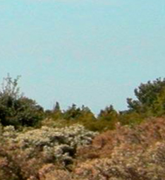
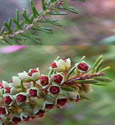
The vegetation of the La Calma High Plateau is divided according to type into: wet meadow 11% (Festuco-Brometea erecti), dry meadow 10% (Thero-Brachypodietea and Festuco Brometea erecti), bracken 13% (Pteridium aquilinum L.), heath 9% (Calluno-Ulicetea), heather (Erica scoparia and E. arbórea, Lavandulo-Ericetumscoparie and Centaureo Pectinatae-Ericetum arboreae), broom 15% (Calluno-Ulicetea), mixed 18% (mix of heather and transition vegetation to forest masses).
GEOLOGY AND SOILS
Geologically speaking, Pla de la Calma is made up of compacted sedimentary rocks deposited during the Mesozoic and Cenozoic eras some 300 million years ago. The soils are not very deep (50-60 cm), are Entisol type (according to Soil Taxonomy) or ranker (according to French classification).The pH is slightly acidic, with no carbonates and a loam-sandy texture. The emergence of large sandstone plates is often found in the pasture areas or in old crop fields.
ENVIRONMENTAL PROBLEMS ASSOCIATED WITH PE
In Europe, one of the most interesting habitats for the conservation of biodiversity and, at the same time, most affected by loss and fragmentation processes are semi-natural pastures (Pino et al., 2011). The Habitats Directive (92/43 / CEE) and the European network of natural protected parks (Red Natura 2000) considers most meadows and pastures, from the alpine floor to the low land, as natural habitats of community interest. At Montseny, and specifically in the zone of Pla de la Calma, there is a great livestock tradition dedicated to the forest pasture, meadows and lands (the presence of farming communities is documented from Neolithic times (Bosch et al., 1991)). Today, though, animal and human action that has been modelling the vegetation and maintaining the landscape are clearly falling due to the abandonment of traditional activity. These changes are causing the reforestation of what were meadows, with the resultant loss of open landscapes comprising high ecological value habitats and habitats of community interest.
USE OF CONTROLLED FIRE
In 1978, when the Montseny mass was declared a natural park, the use of fire was prohibited. The traditional practice of farmers and shepherds doing local burns to maintain the pastures was abandoned. Therefore, the drop in flocks and shepherds has speeded up in recent decades and the control they exercised over the vegetation (usually with the help of appropriate mechanical works) is not enough to stop the progress of wood formations. It was from 2008 when the managers of the Natural Park proposed incorporating the use of fire as a tool to recover open spaces and encourage the development of herbaceous species suitable for grazing. In March 2013, the first prescribed burn (2.3 ha) was carried out in areas of semi-natural meadows for cutting abandoned for their recovery and for research purposes at the same time. The land to be burned was split into four zones for the study and were monitored for two years: zone with burn, zone with burn and grazing, clearing zone and clearing and grazing zine. A zone was also reserved for control and a control with grazing. The second burn was carried out in March 2017 on mixed heather, heath and broom lands that colonise dry meadows. Also, for research purposes, eight plots were established in the burned zone and four in the control zone, with and without grazing exclusion. The final opinion of the agents involved (scientific managers, farmers, firemen and the tourist sector) is very positive.
CENSUSES OF GRAZING HERBIVORES
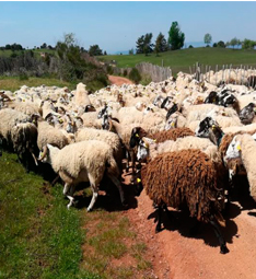
The surface area is grazed by a flock of 700 indigenous Ripollesa sheep breed in transhumance regimen (motorised), the males being with the females all year. Births take place, with a special incidence in December and March, when the animals are housed. The flocks graze Pla de la Llacuna from late March to late November. They start at 8 h, with a minimum rest of 7 to 12 hours and graze 4 to 7 hours covering 5 to 8 different km, guided by a shepherd and a dog. For the pilot experience, the presence of the flock was scheduled every other day, with guided grazing so that the animals pass through and graze in the experimental zones. After the burn, the skeletons of the dead bushes can make passage difficult. To resolve this obstacle, the aim is to incentivise the livestock with salt blocks in the burned area.
FARMING INFRASTRUCTURES AND ACCESSES
At Pla de la Calma there are six exploitation units formed for the flock, grazeable surface area and built elements, though today only three flocks of sheep and goats graze (el Boscàs, La Cortada and el Molar) and one flock of sheep (el Bellit). The first three are engaged in traditional grazing (long displacements during the cold season and permanent installation in summer. In the case of the flock at the el Bellit estate that participates in the pilot experience, the motorised transhumance system has been adopted from Cantonigròs (Osona) in Barcelona province. The study zone is accessed by the unpaved path that goes from Collformic to Ca l’Agustí or from Tagamanent along a paved path. The zone has different short cuts (el Sot de la Llacuna and one natural watering hole, La Llacuna, which gives the place its name). The animals sleep in the del Bellit pen located 1.5 km from the zone where the pilot experience is carried out.
#CalidadSuelosAplicacionesMedioambiente
Follow us


Project financed 75% by the European Regional Development Fund

Universidad Publica de Navarra
Edificio Jerónimo de Ayanz, Campus Arrosadía
31006 Pamplona