


- Inicio
- Trabajos en curso
- PILOT EXPERIENCE IN GALICIA
PILOT EXPERIENCE IN GALICIA
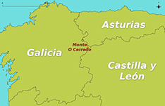
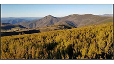
LOCATION
- Monte O Cerredo, Rao, Ancares lucenses
- Coordinates: 42 ° 53’13.8 “N 6 ° 50’26.4” W
- Altitude range: 1394 m to 1392 m
- Municipal district: Navia de Suarna (Lugo)
- Property of the land: Neighbors of Murias de Rao (MVMC)
PROTECTION FIGURES
Biosphere Reserve: “OS ANCARES LUCENSES AND MONTS OF NAVIA, CERVANTES AND BECERREA” (CONSTITUTIVE MEETING 16/11/2011 – San Román de Cervantes)
ZEC (Special conservation area): Ancares-Courel (ES1120001) Galego Decree 37/2014
ZEPA (Special Protection Area for Birds): Ancares (ES0000374) (Master plan of Rede Natura 2000. Galego Decree 37/2014)
ZEPVN (Zone of special protection of the natural values): Ancares (Decree Galego 72/2004)
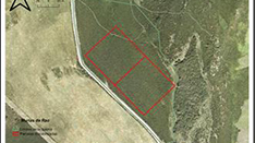
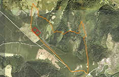
SURFACES OF PERFORMANCE
Two 2 ha areas have been selected for the combined and monitored practices of controlled burning and directed grazing. The targeted use for the improvement of these surfaces will be complemented with the grazing of improved pastures that occupy around 200 hectares of the neighborhood in common hand (MVMC). The 6-month-old equine livestock once the grazing is finished is sold for subsequent bait and sale for meat when it reaches an age of 10 months.
WEATHER
Oceanic mountain, characterized by mild temperatures in summer and very rigorous in winter, being frequent precipitation in the form of snow. The average annual temperature is 8.34oC with maximum in the months of June, July and August around 27oC and the minimum in the months of January and February below -5oC. The average precipitation of 1,113 mm (meteorological station of Ancares, Cervantes).
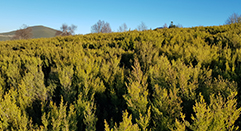
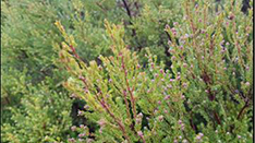
VEGETATION
Almost all the vegetation is scrub (85%, according to the SIOSE of 2014), being the majority Erica australis and Erica arborea, which have a homogeneous distribution, among which are also homogeneous and to a lesser extent Calluna vulgaris, Cytisus scoparius, Chamaespartium tridentatum and Daboecia cantabrica. In addition, there are some Ulex minor spots that account for 5% of the scrub. The rest of the coverings are: high mountain pasture (5%) and deciduous trees (Betula pubescens) (5%), leaving the remaining 5% dedicated to bare soil with a firebreaking function. In the two hectares of study there are two markedly different shrub areas with a large area dominated by lower and more dispersed vegetation and another part with denser vegetation.
GEOLOGY AND SOILS
The geological material of the area is dominated by a combination of sandstones, siltstones and shales with turbiditic facies with contact metamorphism, as well as metamorphic rocks in a geomorphology of embossed reliefs. According to the FAO classification (WRB 2014) in this area there are leptosols, umbrisols or overflows, which correspond to the classification of ESDA with entisoles or incetisoles. They are strongly acidic soils, of loamy silt texture with high total nitrogen content, with a high fraction of aluminum change associated with the acidity of the soil. The soil is limed in case of pasture creation, which did not occur in the area where the trial will be developed.
ENVIRONMENTAL PROBLEMATIC ASSOCIATED WITH THE EP
These silicate breccia of the association Pterosparto tridentati-Ericetum aragonensis are frequent in the eastern Galician mountains and are included in the dry Mediterranean heathland, habitat of community importance within the framework of the Natura 2000 Network, since the Sierra de los Ancares is located in the ZEPVN Ancares-Courel. In the last century they have undergone a process of progressive abandonment, as they have disappeared or reduced considerably, such as grazing, the removal of debris and firewood or the periodic clearing for the cultivation of cereals (dug or estivated), factors that have increased the risk of fires. In the Sierra de los Ancares in the last decades, important areas of these heaths have been transformed into artificial pastures, in order to improve livestock use in those parishes more dynamic from this point of view. These are immature communities that if they are not periodically rejuvenated (rozas, controlled burning, grazing …) evolve into tree-lined formations, usually starting with the birch.
Being high heaths are plant formations that accumulate high levels of biomass, which is why fires are often intense and difficult to tackle, as we often find very steep slopes and ravines, where the chimney effect can make the uncontrollable fire. We must also take into account climate change, whose consequences in terms of number of fires and intensity and peculiarities of them have already suffered in recent years, an effect that is expected to increase in the coming years. The use of rejuvenation practices in these ecosystems, such as controlled burning, making rotations so that they do not affect very large areas every year to reduce soil loss due to erosion and negative visual impact, are advisable to prevent fires and mitigate their fires. effects, at the same time that we contribute to the permanence of this habitat of community importance. Climate change is accelerating the risk of fire.
USE OF CONTROLLED FIRE
In Galicia the use of controlled fire in the generation of pastures is a traditional practice, carried out in the winter season for the control of the scrub mainly, and is regulated by the Autonomous Administration to reduce the risk of fire (Lei 3/2007, de 9 of April, of prevention and defense against the forest fires of Galicia, modified by the Lei 7/2012, of June 28, of mounts of Galicia). The legislation prescribes a period of time in which these practices can be carried out, being necessary the participation of special brigades (EPRIF crews). This ensures that the damage that the fire makes on the ground is minimal (not exceeding temperatures of 20oC). The burnings must be carried out between December and April, being its optimal period between January and March, the wind speed must not be higher than 15 km / h or less than 2 km / h. The ambient temperature must not exceed 15oC, nor be below 5oC, it is also necessary that the relative humidity does not fall below 20% (optimum 35-65%). In addition, they have to spend a minimum of three days without rain and no more than seven (or, at most twelve).
CUSTOMS OF PASTANT HERBÍVOROS
The area of the municipality is just over 24,000 hectares of which 85% is forest land (62% arboreal, 38% scrub and pasture) and 12% is dedicated to crops and meadows. In the last agrarian census there were 2,170 livestock units (UG) in the municipality, of which 80% were bovine, 9% equine, 7% swine and only 2% sheep, with the caprine hut practically residual. The number of bovine heads per farm in the municipality went from 14 in 2002 to 25 in 2016 and 2017 due to a drastic reduction in the number of farms without a noticeable variation in the number of bovine heads. In the study forest there were 117 cows, with 12 horses and 6 colts in 2018, a figure that remains in the current year. For the pilot experience, the presence of 3 to 2 mares per hectare has been programmed. The animals will move to other plots as soon as the offered pasture is limiting, returning to the plot as soon as it has acceptable acceptable pasture.
LIVESTOCK INFRASTRUCTURES AND ACCESS
The study area is in a neighborhood mount in common hand (MVMC) belonging to the residents of Murias de Rao. The study area is accessed from Pobra de Navia, capital of the municipality, along the LU-P-3508 road to the Murias de Rao nucleus, where a detour to Pan do Zarco will be taken. It is also possible to access from Ponferrada on the road LE-CV- 126/13.
In the area there is the following infrastructures to drink (tank is loaded and taken to the mountain) and management sleeve, is also available near the Courel Scientific Station that directs a member of the USC and where you can take courses Of summer. It has a significant influx of cyclists who climb the Ancares port, several times the final stage of the cycle.
Date:
20 February 2019
#CalidadSuelosAplicacionesMedioambiente
Follow us


Project financed 75% by the European Regional Development Fund

Universidad Publica de Navarra
Edificio Jerónimo de Ayanz, Campus Arrosadía
31006 Pamplona