


- Inicio
- Trabajos en curso
- DESCRIPTION OF THE PILOT EXPERIENCE IN THE PYRENEES-ORIENTALES
DESCRIPTION OF THE PILOT EXPERIENCE IN THE PYRENEES-ORIENTALES
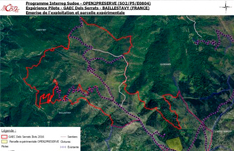
LOCATION OF THE EXPERIMENTAL PLOT
- Common situation: GLORIA
- Small area: High ASPRES-CONFLENT
- Department: ORIENTAL PYRENEES Country France.
- GPS coordinates: 42 ° 33’N; 2 ° 33’E.
- Altitude: 1,250 m.
- Orientation and slope: situation against the wind, moderate slope, northeast orientation.
- Soil condition: property of GAEC DELS SERRATS.
FORMS OF PROTECTION
Form of protection: ZNIEFF1 ” Massif des ASPRES ” – National ID: 910010874 – Regional ID: 66140000 (100% of PE).
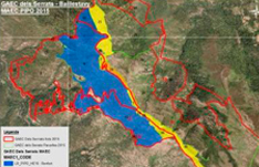
Natural risks: this territory is strongly subject to fire risk. This operation is committed under a MAEC DFCI2 agro-environmental contract. The objective of this contract is to maintain a fuel cut (firewall) on the crest of the farm’s territory (SERRAT DEL GINEBRE). As part of this contract, the non-mechanized part of the cutting area must be maintained with the burning and grazing established to maintain its continuity. This cut is served by the track accessible to CCF 2 0003 and VLTT4.
AGROBUSINESS OPERATION
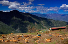
The GAEC DELS SERRATS farm has a territory of almost 330 hectares located in the cities of BAILLESTAVY and GLORIANES (66). Territory of half mountain, is located in the skirts of the massif CANIGOU. Its altitude is between 570 and 1350m. The control of the land is assured by the ownership of the land (the majority), the rent and the lease of the community.
This territory is composed entirely of pastures: 30% of grazed wood (green and pubescent oaks, beech) and 70% of heaths (moors with sarothamnes and ferns, heather calluses).
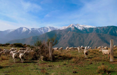
It is an outdoor pastoral exploitation, which includes a herd of suckling pig (~ 50 to 60 of the Aubrac breed) and sheep meat (~ 30 breeders of the Central Central Massif breed). These breeders are committed, for the valorisation of their meat, to local quality brands marketed by the local cooperative (” El Xaï ”, ” Rosée des Pyrénées ”).
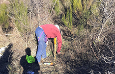
The farm is equipped with a semi-open housing for livestock with feeders for feeding and restricting livestock and a wooden pen (used mainly for childbirth), tractors and rotary cleaners for the maintenance of the farm. territory.
The farm does not use a collective pasture and manages its territory in large fenced parks (active electric fences), through rotating grazing as the seasons pass. Its maintenance is done through gyrobroyages, prescribed burns and reasoned grazing. There is no own production of fodder or cereals.
The challenge of this exploitation is to optimize the potential and the use of the pastoral resource.
The breeders Jean Claude COULET and Birgit POHLE are committed to professional mandates (in particular, the director of the PO Breeding Society, the professional manager of the DFCI and the Directed Burning Cell 66).
DESCRIPTION OF THE PILOT PLOT
The experimental plot was selected within the territory of GAEC DELS SERRATS to house the pilot project SUDOE OPEN2PRESERVE.
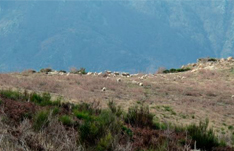
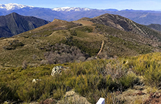
This pilot plot covers an area of just over 7 hectares, included in a homogeneous wasteland of 13 hectares. It is representative of the entire farm in terms of vegetation and soil.
Its location was chosen due to its membership in the controlled burn program validated by the BD Commission of 20175, its ease of access (on the edge of the track) and the proximity of a fence (for the defense of the control plot ).
WEATHER
GLORIANES has a warm Mediterranean climate with dry summer (Csa) according to the KÖPPEN-GEIGER classification. The average temperature in GLORIANS is 15.5 ° C, and the average precipitation 540.3 mm. The hottest month is the month of July and the coldest January.
VEGETATION
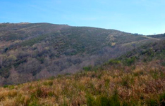
The territory of GAEC DELS SERRATS is located on the ridge and on the east and west flanks of SERRAT DEL GINEBRE, and on the north face of Sainte-Anne. In the different slopes, we find the same type of vegetation, only the proportions and their developments vary.
The lower areas and ravines are mainly composed of oaks (Quercus ilex) and pubescent trees (Quercus pubescens), beech forests (Fagus sylvatica).
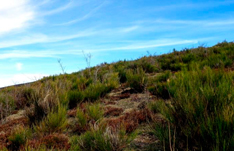
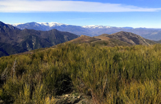
The medium areas are páramos of the type ” Sarothamne moor and Eagle fern – INT.L4 ” and ” Mande à Callune-INT.L1 ” according to the pastoral manual. The vegetation is characterized by a large presence of broom or sarothamn (Cytisus scoparius), bramble (Rubus fructicosus), wild rose (Rosa canina), prunus (Prunus spinosa) and fern fern (Pteridieum aquilinum), scattered. some hard woods
Note: areas maintained by intermittent and prescribed burns are colonized intermittently by the endangered and invasive Cape Sandwich (Senecio inaequidens).
The high areas are formed by heaths with calluna (Calluna vulgaris) and good mountain meadows (mainly on the ridge).
The experimental plot is characterized by a discontinuous páramo of brooms of medium and medium density, and Callunes, dotted with wild roses and scattered trees. The herbaceous layer is a good mountain lawn.
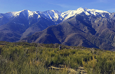
GEOLOGY AND SOILS
The massif is characterized by the presence of crystalline rocks of the primary era as a result of the rising of the PYRENEES. It is mainly shales that form steep landscapes carved into V-shaped valleys covered with dense forests and forests. Its dark colors, sometimes tinged with rust or green, strongly mark the landscapes. The substrate of this site is particularly acidic.
In addition, we can observe the presence of natural sources and water points throughout the farm.
USE OF DIRECTED BURN IN THE EASTERN PYRENEES
The fire has always been used by the breeders of the Pyrenees.
This practice commonly known as “burning” refers to the partial destruction of standing plants in winter conditions. Your goal is:
control of invasive vegetation and rejection of animals, for non-mechanized areas,
Reopen heavy or partially entangled spaces.
Worldwide, ecobuage contributes to the maintenance of open spaces where animals are no longer enough. If the objective is usually the improvement of vegetation for pastoral purposes, fire can also have other effects, such as defending forests against fires (by creating or maintaining support zones for forest services). fighting during the summer fires), or the maintenance of biodiversity … This technique is practiced in almost all the pastoral areas of the department and the Pyrenean chain. However, it is not used in high-risk sectors.
The use of fire and, more particularly, the burning of standing plants is regulated by the Forest Code. In the Eastern Pyrenees, the use of fire is subject to the permanent prefectural decree of August 28, 2013 (currently under review). It may be prohibited in the context of temporary orders.
Thus, in the prescribed department burns / ecobuages more than 1 ha are subject to the authorization of the Departmental Commission of Burning Directed. This consultation committee is multidisciplinary (includes: communities, control services, representatives of breeders, hunters, foresters, managers of natural areas, environmentalists …). It remains under the auspices of the instructors’ service of the prefecture (Departmental Directorate of Territories and Sea 66). Its function is to approve or not the burning projects, add additional requirements, reduce the area or volume of the project, if justified, and allow a concerted organization of the sites. Thus, projects can be authorized for a maximum duration of 5 years.
For almost 30 years, the Operative Unit of Burning 66 of the Breeding Society of PO, operator, has treated about 26,000 ha for burning, at the request of the breeders (25% of the pastoral areas of the department).
Each year, around a thousand hectares of pastures are kept burning in the department.
The cell uses fire professionals. Shipyards under their responsibility are supervised by site administrators authorized by the civil safety enforcement school. Most of the time they are managers of the Fire and Rescue Service of Department 66 or Civil Security (as part of their military training).
The objective is to open the environment in a discontinuous manner to facilitate the access of animals to grazing and improve the resource, while creating a favorable mesh for wildlife and biodiversity.
This implies doing it according to the optimal climatic conditions. In fact, spot burning should be done when the vegetation is dry enough to be combustible; during the winter period, when vegetation is not in sap; and with a light northwest wind, because the vegetation is discontinuous. The soil must also be in good condition (wet or frozen) so as not to sterilize the soil and, therefore, compromise the new growth of the grass.
AN ENVIRONMENTAL PROBLEMATIC ASSOCIATED WITH EP.
The exploitation was created by Jean Claude COULET in 1995, who carried out an important work of pastoral reconquest. Many opening burns and maintenance were carried out in this territory.
These burns are pastoral and DFCI for some fuel cutting plots.
Even if the breeder is one of the few breeders allowed to burn parcels greater than 1 ha6 without using the directed combustion cell 66, it is very likely that the experimental plot will burn to the CDB66.
The preliminary burning of the experimental plot was carried out in March 2009 by the CDB66.
ANIMAL CENSUS PATURING THE AREA
The experimental plot is pastored during the summer season (late spring – early autumn, depending on the resource), by the herd of sheep and cows (1 LU?).
MULTIPURPOSE AND FREQUENT
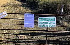
Emblematic, the massive ASPRES and CANIGOU are very popular with many hikers and hikers. Traditional recreational activities are hunting, gathering, fishing. Since then, other nature tourism activities have been developed: hiking and mountain biking, climbing, caving, snowshoeing in winter … This can be a negative factor in terms of the environment and pastoralism: it can harm activities livestock, create numerous disturbances in wildlife and develop the risk of fire. For example, the numerous attacks of stray dogs suffered by the herd of sheep cause economic losses (mortalities, mutilations, abortions …) and induced (high stress, interruption of rotations of grazing, decreased reproduction …).
The tourist assistance whose expansion is accentuated, is a subject to integrate in the management of the territory. Therefore, the associations of hikers, hunters or beekeepers … are often consulted during the development of the burning project.
The territory of this farm is accessible from the departmental road D13, then not from the farm track. The site is crossed by hiking trails. In this farm, there is only moderate assistance at the beginning of the experimental plot.
Date:
21 March 2019
#CalidadSuelosAplicacionesMedioambiente
Follow us


Project financed 75% by the European Regional Development Fund

Universidad Publica de Navarra
Edificio Jerónimo de Ayanz, Campus Arrosadía
31006 Pamplona